|
|
|
SEPTEMBER
2014 CAST |
|
|
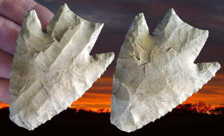
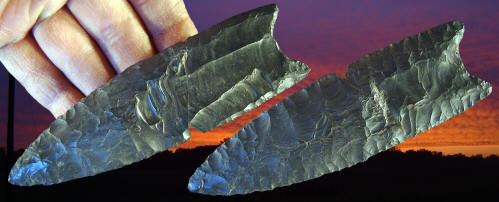
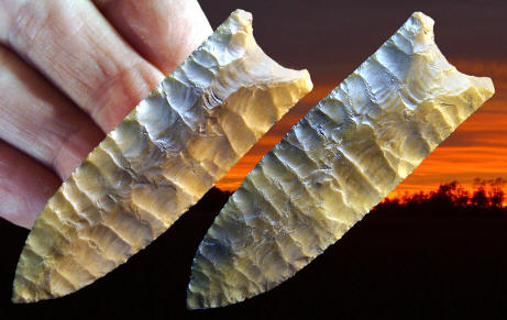
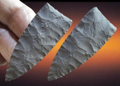
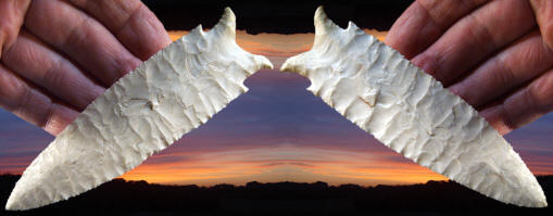
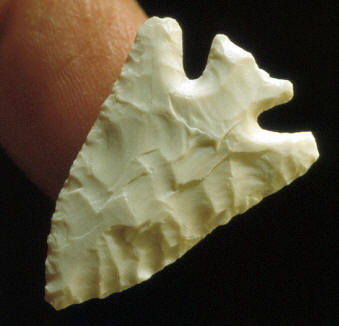
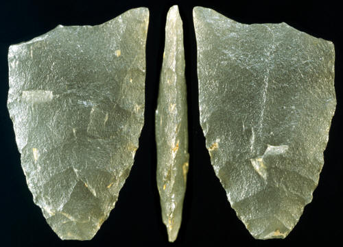
NORTHERN SIDE-NOTCHED
This side-notched point
was
found in 1985 on the DeMoss burial site in west central Idaho. Fourteen
other side-notched points and 20 side-notched point preforms were also
found on the site. It represents one of a group of points that are
assigned to the northern side-notched cluster. However, it might be
difficult to identify specifically. As Noel Justice explains
(2002), "To little is known at present to differentiate new side-notched
types with discrete hafting attributes or tighten the definitions of
Bitterroot (points) and Cold Springs (points) to possibly differentiate
them from Northern (side-notched points)." Northern side-notched points
were named for examples found at Wilson Butte Cave in south central
Idaho. The type description matches several of the points found on the
DeMoss site. |
|
|
AUGUST
2014 CAST |
|
|
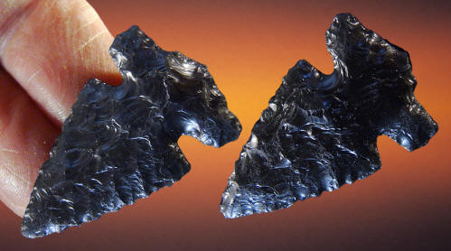
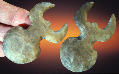
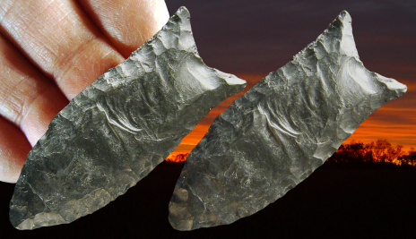
SPIDER ECCENTRIC
SPIDER ECCENTRIC
This Mayan eccentric obviously represents a spider. It has a
large abdomen, a narrow thorax in the center, two legs and what seems to
be small jaws at the front. Although it's a stylized version of a
spider, the large round abdomen and forward directional legs are the
main features that identifies it as an effigy of a spider. This
eccentric is made of Colha chert and it measures 2 3/16 (5.6 cm) long. |
|
|
JULY
2014 CAST |
|
|
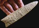
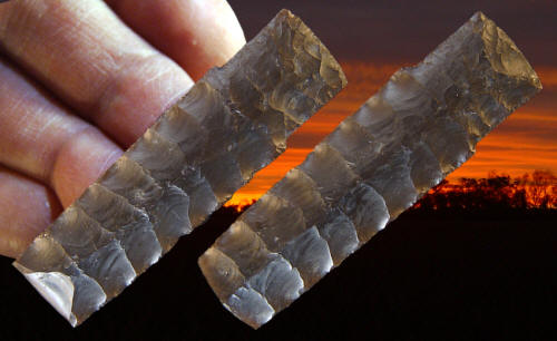
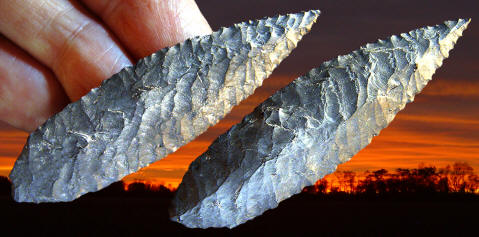
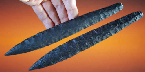
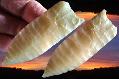
LOWE
POINT
LOWE POINT
This is an excellent example of a Lowe point. It was found on the
type site location in northern Belize on the Lowe Ranch, where the name
for this point was borrowed. The Lowe point type and this point were
first illustrated and described in Kelly's report on "Preceramic
Projectile Point Typology In Belize." The sharply defined barbs, very
large parallel sided stem, and the long narrow flake removals from the
blade edge and base of the stem are some of this points most noticeable
features. "Classic" examples of Lowe points have sharply defined, massive and widely angled barbs. The
stems are ground on the edges and the stems also tend to be very large
and parallel sided and straight to concave on the basal ends. The
cutting edges are beveled from resharpening and often sharp
and
serrated. Some examples
were resharpened with parallel oblique flaking. Their most interesting
diagnostic trait are end thinning flake removals. The stems are
thinned from the base in a way that Kelly (1993) described as
"flake scars that are indistinguishable
from flute scars." Lowe points
are massive heavy duty beveled points that some suggest were probably
only used as knives. But it's very likely they were used for both
projectiles and knives. Many of them do have point impact damage.
This point is heavily patinated and is most probably made of Colha
chert. It measures 3 1/16 inches (7.7 cm) long and 2 1/4 inches (5.7 cm)
wide. |
|
|
JUNE
2014 CASTS |
|
|
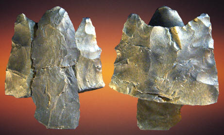
FLUTED POINT BASE WITH REFIT CHANNEL
FLAKE
FLUTED POINT BASE
by Richard Michael Gramly, PhD
Archaeological excavations
during 2013 at the monumental Sugarloaf Paleo-American encampment within
the Connecticut River valley, central Massachusetts focused upon the
“Ulrich Locus” –a manufacturing area of fluted points and bifacial
knives. This ancient workshop is one of six at the Sugarloaf site, and
it may have been used by knappers belonging to a single band of hunters. |
|
|
APRIL
2014 CAST |
|
|
LATE STAGE PREFORM
by Richard Michael Gramly, PhD
Two sizes of fluted projectile
points were manufactured at the monumental Sugarloaf encampment in the
Connecticut River Valley, central Massachusetts. The largest size,
ranging from 125 mm to 175 mm in length (5-7 inches), may have tipped
lances; while, small fluted points such as the one here, may have been
intended for affixing to javelins. Both varieties could have been used
against caribou quarry during their annual migration to and from calving
grounds. |
|
|
MARCH
2014 CAST |
|
|
FLUTED POINT
by Richard Michael Gramly, PhD
This sharp, small-sized fluted
projectile point (SLF-13) evidently had been lost by its maker before it
could be hafted on a javelin or lance. Its lower edges remained
unground. This rare artifact, which is fashioned of Normanskill chert
from a source in the Hudson River Valley, came to light at a rich
workshop (the “Ulrich Locus”) on the Sugarloaf encampment, where as many
as 150 Clovis-style fluted points were manufactured 12,350 +/- calendar
years ago. |
|
|
FEBRUARY
2014 CAST |
|
|
FLUTED POINT
by Richard Michael Gramly, PhD
This remarkable fluted point,
radiocarbon-dated to 12,350 +/- 50 calendar years before present, was
excavated in September, 2013 at the Sugarloaf habitation site, Franklin
County, Massachusetts. Covering four acres, the Sugarloaf Paleo-American
site is perhaps the largest encampment of its era in northern North
America. |
|
|
JANUARY
2014 CAST |
|
|
FLUTED POINT
This Cumberland-type fluted point was
the first of six fluted points recovered from the complex of caves
located on lookout Mountain in Orange County, New York. The escarpment
rises 260 feet above a post-glacial lake of the terminal Wisconsin
period. Originally excavated by the Orange County Chapter in 1965-67,
the area is now a registered National Historic Landmark. |
|
|
DECEMBER
2013 CAST |
|
|
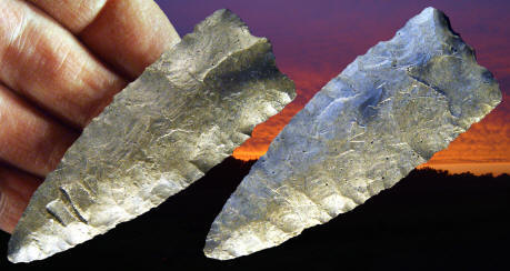
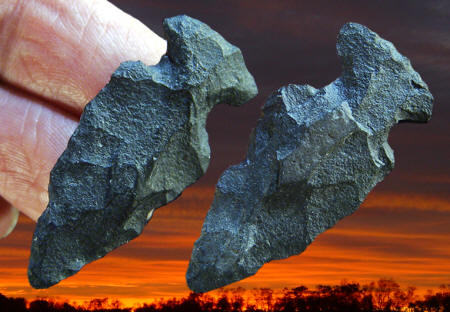
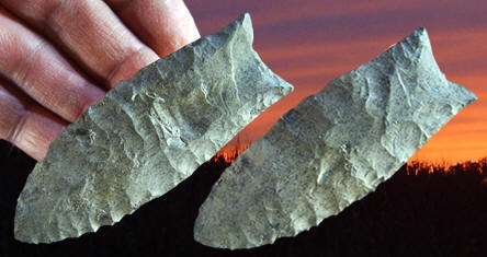
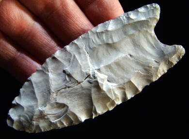
EDEN POINT
This Eden point was found on
the Finley bison kill site in Sweetwater County near Eden, Wyoming
sometime in the 1940's. Although broken it's a good example to show very
uniform collateral pressure flaking and the diamond cross-section of a
skillfully made Cody Complex Eden point. This point was broken from
impact which caused a bend-break type of fracture. It's made from a
semi-translucent dark amber colored chert and measures 2 5/16 inches
(5.9 cm) long. THE FINLEY BISON
KILL SITE
The Finley site is a Paleo-Indian bison kill site. It was discovered in
1939 by O.M. Finley. Various excavations of the site in the 1940's
produced 24 projectile points. Six were classified as Scottsbluff points,
and eight as Eden points. One complete Cody knife was also found.
EDEN POINTS
Eden
points were first discovered in Yuma County, Colorado blow-outs
during the 1930's but none were found in situ until the spring of
1940 when Harold J. Cook spent several days digging in a site
discovered by O. M. Finley. The Eden point was named by H. M.
Wormington after the town of Eden, Wyoming. The Eden type site was
named the Finley site in honor of O. M. Finley who discovered it. |
|
|
NOVEMBER
2013 CAST |
|
|
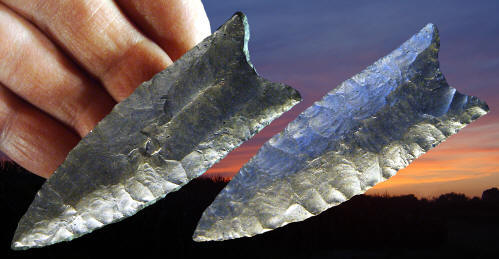
GOSHEN
POINT
CAST #P-112
This Goshen point
was found in the bone bed on the Mill Iron site. Its greatest width is near
the base. The ears are rounded and the basal cavity is ground and the edges
are ground half-way up the point. This point may be made of Hartville chert
and it measures 2 13/16 inches (7.1 cm) long. MILL IRON SITE
The Mill iron site is
located in Carter County, Montana in the southeastern part of the state.
It's now believed that it represents the Goshen Cultural Complex as it was
described at the Hell Gap site in southeastern Wyoming. There are now five
accelerator dates on the site that average over 11,000 years before present.
It remains to be proven if Goshen is a Clovis variant or if it should be
placed somewhere between Clovis and Folsom. |
|
|
OCTOBER
2013 CAST |
|
|
GOSHEN
POINT
CAST #P-111
This Goshen point is one of the
more skillfully made points from the Mill Iron site. Both sides have fairly
uniform parallel pressure flaking. The fact that one side is flat may
indicate that it was made from a flake blank. The sides are parallel and the
edges were sharpened and straightened with fine retouch pressure flaking
between the flake scars. The basal concavity is uniformly curved and the
ears are squared. Basal thinning was accomplished with the removal of
several pressure flakes on both sides. This point was broken in the middle
with a bend-break type of fracture that probably happened during use, rather
than during manufacture. This point measures 2 15/16 inches (7.5 cm) long. MILL IRON SITE
The Mill iron site is
located in Carter County, Montana in the southeastern part of the state.
It's now believed that it represents the Goshen Cultural Complex as it was
described at the Hell Gap site in southeastern Wyoming. There are now five
accelerator dates on the site that average over 11,000 years before present.
It remains to be proven if Goshen is a Clovis variant or if it should be
placed somewhere between Clovis and Folsom. |
|
|
SEPTEMBER
2013 CAST |
|
|
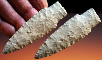
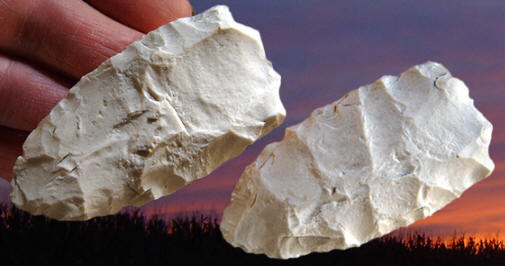
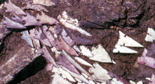
CASCADE
POINT
This Cascade dart point
was
found on the Demoss burial site in west central Idaho in 1985. The
Demoss site was accidentally discovered when a backhoe exposed a large
number of artifacts during the excavation of a spring. This is a late
Cascade Phase site that dates to 6,000 years ago. A minimum of 236
Cascade points, side-notched points, and bifaces were found along with
the bones of at least 60 individuals. Nine percent (22) of the artifacts
were identified as Cascade points. All of them have some diagonal
pressure flaking. This point is made of
dark gray basalt and it measures 2 5/8 inches (6.6 cm) long. |
|
|
AUGUST
2013 CAST |
|
|
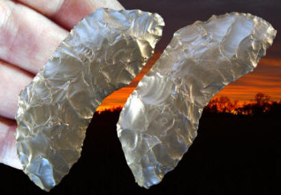
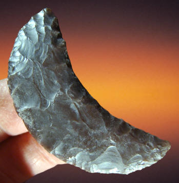
BUTTERFLY CRESCENT This crescent was found in May of 2002 during an archaeological survey on the US Army Dugway Proving Ground in Tooele County, Utah. The project was called the Lake Oferneet Survey. It was found within a geological formation known as The Old River Bed which is an abandoned river delta that flowed onto the floor of the Great Salt Lake Desert and, for some time, into ancient Lake Bonneville. Based on its context, this Crescent may date sometime prior to about 12,000 calibrated years before present. This type or style of Crescent is sometimes referred to as a butterfly Crescent because of its angular edges at both ends. They have the appearance of being resharpened from Crescents that once had uniformly curved edges. Crescent is the term that is most often used to describe these uniquely shaped early tool forms. But in fact, they were actually described and named Great Basin Transverse points by C.W. Clewlow Jr. in 1968. Most crescents are curved with a concave edge on one side and a convex edge on the other so the descriptive word "crescent" is most often used. Some archaeologists believe the Great Basin Stemmed Point Tradition is directly connected to Crescents. This crescent measures 2 1/2 inches (6.3 cm) long. |
|
|
JULY
2013 CAST |
|
|
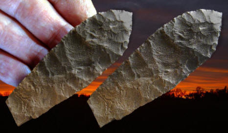
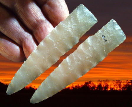
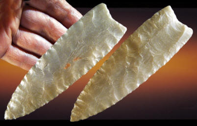
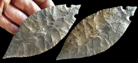
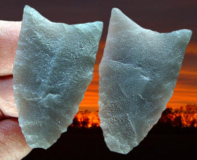
HASKETT
POINT This point was discovered during an archaeological survey in the Great Salt Lake Desert in western Utah. It represents one of the earliest forms of western stemmed points and appears to date sometime prior to about 12,000 calibrated years before present based on its context. These types of spear points are now believed to have been used to hunt large mammals during the late Pleistocene. This point was tested for protein residue and was found to react positively to elephant antisera (blood serum), presumably mammoth or mastodon. It was found within a geological formation known as The Old River Bed which is an abandoned river delta that flowed onto the floor of the Great Salt Lake Desert and, for some time, into ancient Lake Bonneville. The base was broken with a bend-break type of fracture that also caused burin flake removals on both edges. This Haskett point is made of black basalt and it measures 3 3/8 inches (8.6 cm) long. |
|
|
JUNE
2013 CAST |
|
|
HASKETT
POINT This is the largest Haskett point ever documented archaeologically. It was discovered during an archaeological survey in the Great Salt Lake Desert in western Utah. It represents one of the earliest forms of western stemmed points and appears to date sometime prior to about 12,000 calibrated years before present based on its context. These types of spear points are now believed to have been used to hunt large mammals during the late Pleistocene. Evidence of this comes from another Haskett point found nearby, which reacted positively to elephant antisera (presumably mammoth or mastodon) when tested for protein residue. Both of these points were found within a geological formation known as The Old River Bed which is an abandoned river delta that flowed onto the floor of the Great Salt Lake Desert and, for some time, into ancient Lake Bonneville. This point was found in two pieces within a few feet of each other. The base was cleanly broken with a bend-break type of fracture 1 7/16 inches (3.6 cm) from the base. It's made of black basalt and it measures 8 13/16 inches (22.4 cm) long. |
|
|
MAY
2013 CAST |
|
|
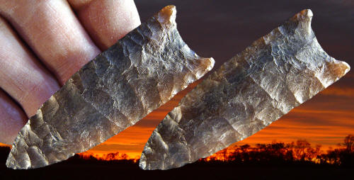
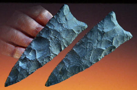
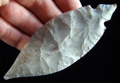
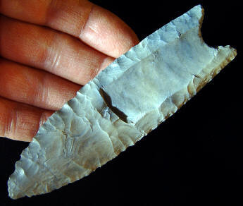
SIDE-NOTCHED POINT
The Wallace Ruin site is a
multi-storied Ancestral Pueblo near Cortez, Colorado. The site produced
projectile points from both Early and Middle Archaic periods and later
period Basketmaker II and III and points from all three Pueblo periods.
This side-notched point was
found during excavation at Wallace Ruin by Bruce Bradley. He identifies
this point "as one of about eight
or nine point types that represent the prehistoric development on the
Colorado Plateau of southeastern Arizona, northwestern New Mexico,
southeastern Utah and southeastern Colorado. An Archaic sequence is seen
that has been termed the Oshara Tradition. This was a high desert
plateau hunting/gathering tradition that shows some relationship to the
lower Desert Archaic and the southern Great Basin Archaic. |
|
|
MARCH
2013 CAST |
|
|
FOLSOM
POINT ORIGINAL
POINT ILLUSTRATED This fluted point was found several years ago in a cultivated field on the Ready-Lincoln Hills site in Jersey County, Illinois. It's an example of an eastern style Folsom point and the only one that was found on the Ready-Lincoln Hills site. Most Folsom points have been found west of the Mississippi River. One side is fluted to the tip and the other side has a small narrow flute that measures 5/8 inch (1.6 cm) long. This point is made of white Burlington chert and it measures 1 13/16 inches (4.6 cm) long. READY-LINCOLN HILLS SITE This site was originally known as the Ready site (pronounced Reedy) and later as the Lincoln Hills site. The Ready-Lincoln Hills site is the largest Early Paleo-Indian camp and stone tool manufacturing site in an area near the confluence of the Mississippi, Missouri and Illinois Rivers. The site is on a cultivated field that measures about 2.7 acres (1.1 ha). The main lithic source was high quality Burlington chert that was available from local outcrops along valley walls and stream beds. The Ready-Lincoln Hills site produced a large collection of Clovis manufacturing debris in the form of broken and discarded fluted bifaces, point preforms and other miscellaneous unifacial tools. The site collection contained 224 fluted bifaces that were determined to be manufacturing rejects. |
|
|
FEBRUARY
2013 CAST |
|
|
EDEN
POINT
Two basic typological
point types are represented in the Horner II site excavation. All but one
example are type I style points. This is the single type II point that was
found during the excavation of the Horner site and it's been identified as
an Eden style. It falls typologically and technologically between the
Alberta and Scottsbluff / Eden points but is considered to be an Eden style.
The flaking is the reason for its type II designation and the decision to
call it an Eden point. Flakes were removed wide enough so they do not
overlap and they were removed uniformly. It's described as being generally
narrower than type one points and the blade edges are less convex. The point
is widest at the shoulders and the thickest area is near the point (distal
end). The cross-section of the blade is lenticular and the cross-section of
the stem is flat. |
|
|
JANUARY
2013 CAST |
|
|
GOSHEN
POINT
This Goshen point is described
by Frison and Bradley as a point that, "is different in shape from the
rest of the points (that were found on the Mill
iron site). It is nearly triangular with
slightly convex sides and has the slightest suggestion of a basal
indentation. We believe that it is very likely that this point resulted from
the all-over reworking of a piece of a broken point." Originally, this point
may have been larger and a
new base was applied after it was broken so it could be used again. This point is made of purple
colored Porcellanite measures 1 13/16 inches (4.7 cm) long. MILL IRON SITE
The Mill iron site is
located in Carter County, Montana in the southeastern part of the state.
It's now believed that it represents the Goshen Cultural Complex as it was
described at the Hell Gap site in southeastern Wyoming. There are now five
accelerator dates on the site that average over 11,000 years before present.
It remains to be proven if Goshen is a Clovis variant or if it should be
placed somewhere between Clovis and Folsom. |
|
|
DECEMBER
2012 CAST |
|
|
CLOVIS POINT This Clovis point was found several years ago in Utah by Greg Nunn. It's a good example of a western style Clovis point or knife. Some of the flaking is oblique and the base is shallow. One side has a large flute flake that is 1 3/8 inches (3.5 cm) long. There are also two small spots of encrusted red ochre on one side that indicates this point may have been in a cache. This Clovis point is made of semi-translucent gray/brown chalcedony and measures 5 3/16 inches (13.2 cm) long and 1 1/2 inches (3.8 cm) wide. |
|
|
NOVEMBER
2012 CAST |
|
|
SCOTTSBLUFF
POINT
SCOTTSBLUFF
POINT
This projectile point was
discovered sometime during the 1977-78, 1980, 1983 & 1984 excavations of the
Horner II site by the University of Wyoming. Earlier excavations of the
Horner site (Horner I) was carried out by Princeton University in 1949 &
1950 and by the Smithsonian Institution in 1952. This point is described as
falling typologically and technologically between the Alberta and
Scottsbluff / Eden points but is considered to be a Scottsbluff style. It
represents one of 21 projectile points found during the University of
Wyoming excavations and only one of five complete un-reworked points. This
point is made of Quartzite and measures slightly over 2 1/8 inches (8 cm)
long. HORNER SITE The Horner site was discovered by Jimmy Allen on July 2, 1939 while he “walked down the (Shoshone) River to Sage Creek, hunting arrowheads.” The site was later recognized as the representative type site of the Cody Cultural Complex. The site was named after Pear Horner, the owner of the land. The Horner site is located in northwestern Wyoming in Park County 4 miles northeast of the town of Cody. The site is also situated on a 150 foot terrace near the confluence of Sage Creek and the Shoshone River. |
|
|
SEPTEMBER
2012 CAST |
|
|
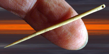
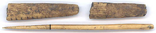
BONE NEEDLE
This bone needle was
found in 1989 during the excavation of the "Buhl Woman" burial.
It was restored before it was cast. Approximately 9/16 inch (1.4 cm) of
the tip of the point is restored. The original length of the broken
needle measured 1 5/16 inches (3.3 cm) long.
This needle also measures 2 mm in diameter
and the eye measures .8 mm in diameter. Microscopic examination of the
eye of the needle suggests that it was formed by gouging, rather than
drilling, with a hand-held perforator.
CASTS ILLUSTRATED
This picture shows three casts of bone artifacts that were found with
the Buhl burial. The black line on the bone needle indicates where it was
originally broken. The
other two bone pieces have been described as fragments belonging to
possibly a single awl or pin. The broken segment on the left has 11
engraved lines cut along the edges. |
|
|
AUGUST
2012 CAST |
|
|
AZTEC RITUAL KNIFE
AZTEC RITUAL KNIFE
This is a cast of a typical example of an Aztec biface. Aztec bifaces
are reported to have been used in blood sacrifices and buried in ritual
offerings as "personified" forms of different deities. Bifaces like this
have been found in excavations of ceremonial caches in the ancient Aztec
city of Tenochtitlan that is now located under the modern day city of
Mexico City. These unique ritual tools are also referred to as Aztec
knives. This biface measures 6 13/16 inches (17.3 cm) long. This biface
measures 6 13/16 inches (17.3 cm) long. It's made of a semi-translucent
brownish/red colored tabular chert that was commonly used by Aztec
flint-smiths. |
|
|
JULY
2012 CAST |
|
|
MICRO-DRILL
CAST
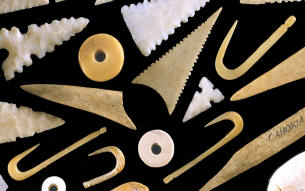
M-17 This micro-drill was discovered on the Cahokia Mounds site within an area of about 3.7 acres on the Kunnemann tract where many thousands have been found. These small drills were once hafted onto reed shafts and used to drill holes in shell and other soft organic materials. Most of these types of drills were probably used to make beads. The Cahokia people were manufacturing very large numbers of shell beads. At least 60,000 drilled shell beads were found in Mound 72 at Cahokia. These were divided into seven different main types or styles and within those there were other subtypes based on size and form. Bead making experiments have shown that it takes about ten minutes to drill one bead. At this rate it would have taken 1,250 eight hour days of steady work to complete the drilling part of the process to produce the 60,000 beads that were found in Mound 72. This micro-drill is made of white Burlington chert and it measures 1 1/16 inches (2.6 cm) long.
|
|
|
JUNE
2012 CAST |
|
|
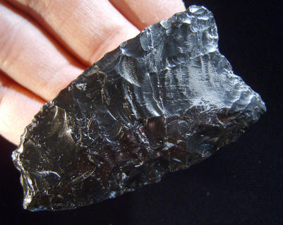
CLOVIS BIFACE
CLOVIS BIFACE This is one of the more interesting bifaces in the Fenn cache because it has the best example of an over-shot flake removal. One flake removed nearly 4 inches (3 13/16 inches (9.7 cm) of an opposite edge. Another smaller over-shot flake can be seen near the point. The opposite side has an over-shot flake that measures 2 inches (5.1 cm) wide. This biface is made of opaque black Obsidian and it measures 7 5/8 inches (19.4 cm) long. |
|
|
MAY
2012 CAST |
|
|
CLOVIS CRESCENT
CLOVIS CRESCENT This is the only crescent found in the Fenn cache and in fact it's the only known example ever found in a Clovis cache. It's described as having sharp edges at both ends but the middle area on both sides have been dulled by grinding. Although the known history surrounding the discovery of the Fenn cache is not what everyone would like. This crescent does seem to belong to the assemblage because it is made from the same Green River Formation chert as other artifacts in the group and it's also coated with red ochre. Crescent is the term that is most often used to describe these uniquely shaped early tool forms. But in fact, they were actually described and named Great Basin Transverse points by C.W. Clewlow Jr. in 1968. Most crescents are curved with a concave edge on one side and a convex edge on the other so the descriptive word "crescent" is most often used. Some archaeologists believe the Great Basin Stemmed Point Tradition, which is a possible source for this crescent, is either directly or indirectly connected to Clovis. Indirectly because these types of stemmed points are believed by some to predate Clovis. So this crescent may help to establish that the Great Basin Stemmed Point Tradition (also referred to as the Western Stemmed Point Tradition) was either contemporaneous with Clovis or possibly older than the Clovis culture. Another source describes crescents that have been found on the surface in California along with small Clovis-like points. This crescent measures 2 3/8 inches (6 cm) long. |
|
|
APRIL
2012 CAST |
|
|
FULTON
TURKEY TAIL
FULTON TURKEY TAIL
This is an exceptionally
well made example of a Fulton Turkey Tail. It's been published in six
different publications where its been described as being quintessential
(most perfect). It was found by Dean Burke in 1964 while surface
collecting in a field near Lebanon, Illinois in St. Clair County. Two or
three additional broken Fulton Turkey Tails are rumored to also have
been found at the same location. |
|
|
MARCH
2012 CAST |
|
|
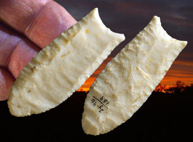
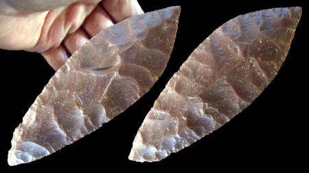
SUWANNEE POINT
This Suwannee point was
found many years ago in the Santa Fe River in Gilchrist County, Florida.
It's made of a black colored chert that is not the best quality. But
this is a good representative example of a Suwannee point. It measures 4
3/8 inches (11.1 cm) long. "REFERENCE" 2006, Dunbar, James, Webb, David S., "Paleoindian Archaeology," First Floridians And Last Mastodons: The Page-Ladson Site In The Aucilla River, p.408-409. |
|
|
FEBRUARY
2012 CAST |
|
|
CLOVIS POINT This Clovis point was found several years ago by David Olmstead while digging on the Gault site in Williamson County, Texas. He found it near some engraved limestone water worn pebbles. This point is slightly "fishtailed" and it was fluted at least three times on one side. This point is made of a good quality gray colored chert. It measures 3 3/8 inches (8.6 cm) long and 1 3/16 inches (3 cm) wide. The Gault site is located in south central Texas in Williamson County and covers an area estimated to be a half mile by a little over a tenth of a mile wide (0.8 by 0.2 km). The site is classified as a stone tool manufacturing and habitation site. The Gault site has produced Clovis points, point preforms, tools made from blades, cores, burins and small engraved stones. Recent excavations (1998--2002) by archaeologists from the Texas Archaeological Research Laboratory at the University of Texas at Austin has recovered approximately 800,000 artifacts. One of the most important artifact types to have been recovered on the Gault site are the engraved stones. By 2001 at least 30 engraved stones had been found. Their direct association within the Clovis horizon at Gault is a significant discovery. Engraved stones from this early period in North America is almost unknown. In 2002 there was an important discovery of a 6 by 6 foot pavement of gravel that has been interpreted as evidence for one of the earliest man-made structures found in North America. |
|
|
JANUARY
2012 CAST |
|
|
GOSHEN
POINT
GOSHEN
POINT
This Goshen point is described
by Frison and Bradley as "an exquisite example of highly controlled pressure
flaking." It was basally thinned with the removal of multiple thinning
flakes on both sides. The edges were straightened and sharpened with fine
pressure retouch. Part of one of the basil "ears" is missing on this point.
It was made from silicified wood and it measures 2 3/4 inches (7 cm) long. MILL IRON SITE
The Mill iron site is
located in Carter County, Montana in the southeastern part of the state.
It's now believed that it represents the Goshen Cultural Complex as it was
described at the Hell Gap site in southeastern Wyoming. There are now five
accelerator dates on the site that average over 11,000 years before present.
It remains to be proven if Goshen is a Clovis variant or if it should be
placed somewhere between Clovis and Folsom. |
|
|
DECEMBER
2011 CAST |
|
|
FULTON
TURKEY TAIL
FULTON TURKEY TAIL
This Turkey Tail point was found several years ago in
a cultivated field in Clinton County, Illinois. The majority of well
made Fulton Turkey Tail points, like this example, have been found in
caches. So it's likely that this point was part of a cache of other
points. It's made of Indiana Hornstone and it measures 4 5/16 inches long. |
|
|
SEPTEMBER
2011 CAST |
|
|
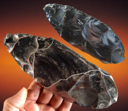
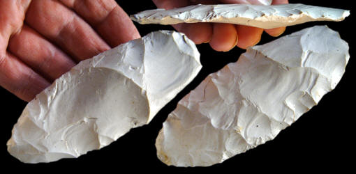
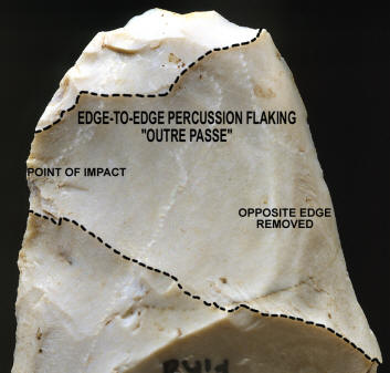
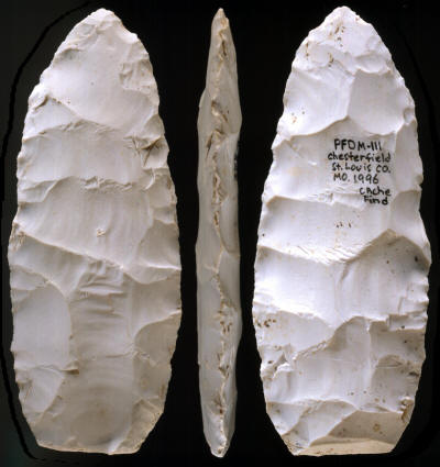
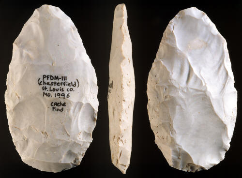
BIFACE
This early stage biface represents one of the 11 bifaces (see
McKinnis cache) that were discovered during a land leveling operation in St.
Louis County, Missouri. It's an early stage biface that illustrates
"classic" Clovis flake removal scars. This biface is most
impressive for its
edge-to-edge or "outre passe" style of flaking. One side has a
large edge-to-edge flake scar that removed 1 1/2 inches (3.8 cm) of the
opposite edge. This is a lithic technology that was no longer
traditionally used in post-Clovis cultures. The intended purpose for
this early stage preform was probably to make a fluted point. This
biface is made of Burlington chert and measures 4 5/16 inches (11 cm)
long, 1 11/16 inches (4.3 cm) wide and 7/16 inch (1.1 cm) wide. THE McKINNIS CACHE SITE
The McKinnis cache was discovered in 1996 on land that was being
leveled for houses. The cache contained 11 bifaces and 12 core blades. The
site is located on a hill top within 2 miles of the Missouri River in St. Louis County, Missouri.
This cache was made with stone tool manufacturing technology that
relates to the Clovis culture. The largest artifact in the cache is
a basally thinned late stage Clovis point preform. A base of a Clovis point was also
found near this cache.
This picture shows a close-up view of the over shot percussion flake scar on
the biface pictured above. This is an excellent example of a Clovis
technology break pattern that is often found on Clovis camp and
manufacturing sites. Over shot flakes are referred to as either
edge-to-edge or "outre passe" types of flake removals.
This flintknapping technique represents an important diagnostic
element of Clovis stone tool manufacturing technology. These unique
and fairly rare types of
flake removals help archaeologists identify Clovis sites. This biface is
made of Burlington chert and it measures 4 5/16 inches (11 cm) long,
1 11/16 inches (4.3 cm) wide and 7/16 inch (1.1 cm) wide. |
|
|
AUGUST
2011 CAST |
|
|
HOLLAND
POINT
This Holland point was
found many years ago in St. Louis County, Missouri. There are several
different styles of Holland points. This point has all the
characteristics of a Dalton point except for the shoulders that might
even be called corner-notched. In fact, this point seems to be a
transitional form of Dalton-Hardin Barbed point. This point is made of white Burlington
chert and it measures 4 3/4 inches long. |
|
|
JULY
2011 CAST |
|
|
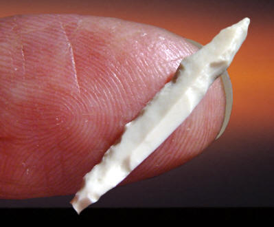
FOLSOM BEAD
This tiny bead was discovered during the excavation of the Shifting
Sands site in Winkler County, Texas. It was actually found stuck onto a
chert flake, otherwise it probably wouldn't have been found at all. In
fact, there may have been more of them. The material has not been
identified but it's thought to be either ivory or bone. It measures
about five or six dermal ridges wide. |
|
|
JUNE
2011 CAST |
|
|
CLOVIS PREFORM
This Clovis preform was found several years ago by a road maintenance crew
member somewhere in the St. Louis by-state area. A large wide flute was
struck from one side but there is no indication that any further attempt
was made to flute the other side or finish the point any further. The
striking platform remnant on the basal edge has not been altered. This
preform is made of white Burlington chert. It measures 2 13/16inches
(7.1 cm) long and 1 3/8 inches (3.5 cm) wide. |
|
|
MAY
2011 CAST |
|
|
UNFLUTED FOLSOM OR
UNFLUTED FOLSOM OR "MIDLAND" POINT Although broken, this unfluted Folsom or Midland point is an especially nice example. It has fine delicate ears and tiny micro flaking along the edges. Points, like this example, are referred to as either unfluted Folsom or Midland points. Some archaeologists believe they are either a variant of the Folsom point or just a Folsom point that was not fluted. Some of these points have a fluting platform on the center of the base that was never used. The reason for this might be that they were to thin to flute. Its also been suggested that the platform may have become a residual design feature from traditional Folsom point production. Notice that this point does have a slightly raised area in the center of the base that might relate to this description. Midland points were named in 1955 by Fred Wendorf, Alex D. Krieger and C. C. Albritton from examples found on the Scharbauer site near Midland, Texas. This point was found in eastern Wyoming at Goshen Hole on the high Plains where the land is described as a deep depression. This point is made of a semi-translucent dark brown material that is similar in appearance to Knife River flint. It measures 1 1/4 inches (3.2 cm) long. |
|
|
APRIL
2011 CAST |
|
|
BUCK CREEK
POINT
This Buck Creek
point was found in Hardin County, Kentucky. It dates to the Late Archaic
period approximately 3,000 years ago. Buck Creek points were named by
Mark F. Seeman in 1975 after Buck Creek in Harrison County, Indiana
where the type site is located. Large and very well made Buck Creek
points, like this example, are usually associated with caches. They were
probably made for some type of special event, such as for a burial. But
most Buck Creek points were obviously tools that were used every day for
knives or projectile points. They show heavy use from edge resharpening
and various types of use wear damage. |
|
|
MARCH
2011 CAST |
|
|
CLOVIS POINT
This is the first Clovis artifact identified to have ancient adhesive
preserved within the hafting area. It was found several years ago by John Dyck
on the Hoyt site in the Great Basin region of Central Oregon. It's
most important feature is the abrasion scratches located on both
sides on the channel flake scars. Lab analysis by Kenneth B. Tankersley
revealed the presence of an organic hafting adhesive (mastic) in the
striations. Chemical and microscopic analysis identified the material as
amber resin along with possible particulate wood charcoal inclusions.
This is the first documentation of a Clovis point that has it's original
hafting adhesive preserved on the channel flake scars. |
|
|
FEBRUARY
2011 CAST |
|
|
EASTERN STYLE This fluted point was discovered during the excavation of the Lamb site in Genesee County, New York. It was found broken and it was reassembled from two pieces. One side is double fluted and the other side has one large flute. It's reported to be made from Ohio/Indiana chert and measures 3 11/16 inches (9.4 cm) long and 1 9/16 inches (3.9 cm) wide. The Lamb site is located in a cultivated field in Genesee County, New York on an inconspicuous knoll, barely six feet high, bordering Murder creek, a tributary of Tonawanda creek. The farm is owned by Christopher Lamb who surface collected the site adding to a family collection accumulated, over the years, by his father and grandfather. After studying fluted point fragments and preforms in the Lamb collection Dr. Mike Gramly of the Buffalo Museum of Science began excavation of the site in 1986 with volunteer help from the Houghton Chapter of the New York State Archaeological Association. Twelve fluted points and twelve preforms were eventually recovered. All material was found in the plow zone and no evidence of a storage or burial pit was found. It was determined that this material was either a cache by itself or at one time with a burial. |
|
|
JANUARY
2011 CAST |
|
|
EASTERN STYLE This large fluted point was discovered during the excavation of the Lamb site in Genesee County, New York. It was found broken and reassembled from three pieces. It is reported to be made from Ohio/Indiana chert and measures 4 3/4 inches (12.1 cm) long and 1 1/8 inches (2.9 cm) wide. The Lamb site is located in a cultivated field in Genesee County, New York on an inconspicuous knoll, barely six feet high, bordering Murder creek, a tributary of Tonawanda creek. The farm is owned by Christopher Lamb who surface collected the site adding to a family collection accumulated, over the years, by his father and grandfather. After studying fluted point fragments and preforms in the Lamb collection Dr. Mike Gramly of the Buffalo Museum of Science began excavation of the site in 1986 with volunteer help from the Houghton Chapter of the New York State Archaeological Association. Twelve fluted points and twelve preforms were eventually recovered. All material was found in the plow zone and no evidence of a storage or burial pit was found. It was determined that this material was either a cache by itself or at one time with a burial. |
|
|
AUGUST
2010 CAST |
|
|
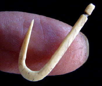
BONE FISHHOOK
BONE FISHHOOK
This bone fishhook was found
several years ago in a cultivated field on the Cahokia Mounds Historic
site. It was found in a cache of six or seven other fishhooks. This
fishhook appears to be made from deer bone and possibly the toe bone of
a deer. An estimated date for this fishhook is somewhere between A.D.
900 to A.D. 1300.
|
|
|
AUGUST
2010 CAST |
|
|
MOUND 72 POINT This point represents another one of the many different types of arrow points that were found during the excavation of mound 72. It was found in one of three caches that all together contained about 1200 projectile points. Only two points in Mound 72 were similar to this example. It was discovered within a large cache that contained several different styles of points. All the points in this cache were laying parallel to each other and generally facing one direction suggesting they were once hafted onto arrow shafts. This wide corner-notched point represents one of the artistic styles that are unique to Mound 72. The barbs are rounded and the blade edges are slightly recurved. This style may have been influenced by some of the Caddoan arrow point types from Arkansas and Oklahoma. This point is made of white Burlington chert and it measures 1 3/16 inches (3.1 cm) long.
Approximately seventeen different styles of arrow points were found in
mound 72. They vary from simple unnotched triangular points to some that
were both serrated and notched with recurved blade edges. They were also
made from many different types of chert such as silicified sandstone,
Burlington, Dover, Kaolin and Pitkin cherts.
|
|
|
JULY 2010
CAST |
|
|
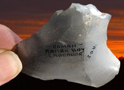
FLUTED
POINT
This fluted point was
surface collected many years ago by a farmer on a site that is believed to
be somewhere in Franklin County, in southwestern Vermont. It was previously
reported by Stephen Loring in an article called "Paleo-Indian Hunters And
The Champlain Sea: A Presumed Association." This point is most important for
the material it was made from. Stephen Loring (Smithsonian) originally
identified the material as Cheshire quartzite which is a material that is
found in north central Vermont. But in his more recent analysis of the point
he was able to identified the material as Ramah chert from Labrador. The
analysis was done with the use of lab equipment such as laser spectrograph
or x-ray diffraction. This would mean that the source is considerably
further away than first thought. In fact, this distance rivals many Early
Paleo transports. A straight line from the find area to the known Ramah
quarry along the Labrador coastline at Ramah Bay measures approximately
1,100 miles but a more probable circuitous route might be closer to 1,600
miles. It's believed that this point is fairly early and dates to at least
10,000 years ago or more.
CLICK ON PICTURE FOR LARGER IMAGE This picture shows three views of the original fluted point before the one ear was restored.
|
|
|
JUNE 2010
CAST |
|
|
CLOVIS PREFORM
This broken base of a fluted preform was recovered from the lower Clovis
horizon at Kimmswick. It was broken when a large end thinning flake was
struck from the base and hinged downward. This broken preform represents
one of the common types of break patterns found on Clovis sites. This
preform was made from a piece of white Burlington (Crescent Quarry)
chert and it measures 1 9/16 inches long.
This Clovis site, once referred to as just "Kimmswick", has had a long
history of excavation. Beginning in 1839 Dr. Albert Koch unearthed
skeletal remains which were later identified as Mammut
americanum
and later sold to the British Museum of Natural History in 1844 where
they are still on display. In 1897 C.W. Beehler rediscovered the site
with new excavations and later built a small on site museum in 1900,
which housed hundreds of bones. Several excavations followed Beehler but
the most extensive were those of Robert McCormick Adams in the 1940’s
who left the most complete record of the site.
|
|
|
MAY 2010
CAST |
|
|
SIDE-NOTCHED POINT This Anasazi side-notched arrow point dates to the Pueblo III Period between A.D. 1100 and A.D. 1300. It was discovered during excavation of the Wallace Ruin site near Cortez, Colorado. This side-notched point was made from a beautiful piece of red Jasper and it measures 1 5/16 inches (3.3 cm) long. ANASAZI ERA by Bruce Bradley, PhD. On the Colorado Plateau of northeastern Arizona, southwestern New Mexico, southeastern Utah and southwestern Colorado the Archaic was followed by a culture termed the Anasazi. This was a generalized village dwelling group which relied primarily on the cultivation of corn, beans and squash. Hunting did remain as part of the food gathering process throughout the Anasazi era. There is growing evidence that warfare may also have played a small role in Anasazi society. The Anasazi era has been separated into two major divisions: (1) the Basketmaker, and (2) the Pueblo. Each of these is further subdivided into social organizations. The Anasazi era is usually considered to fall between A.D. 1 and A.D. 1300. This time was followed by further development of a pueblo dwelling culture which is still existing today in New Mexico and Arizona. |
|
|
APRIL
2010 CAST |
|
|
CLOVIS POINT This large Clovis point was discovered in April, 1988 during the excavation of the East Wenatchee Clovis site. The site is located in central Washington in Douglas County. It was found laying next to three other large fluted Clovis points at the edge of an ancient pit that contained more than 60 stone and bone Clovis culture artifacts. It's believed that this Clovis point has been resharpened one or more times. This point is made of a very pure, translucent clear to white agate that may have been quarried from outcrops among Columbia River basalts east of the archaeological site. It measures 5 5/8 inches (22 cm) long, 2 9/16 inches (6.6 cm) wide and 1/2 inch (1.2 cm) thick.
EAST WENATCHEE CLOVIS SITE One of the most spectacular archaeological discoveries ever made in the study of Early Paleo bone and stone artifacts occurred near East Wenatchee, Washington in 1987. The site is located in an apple orchard near the Columbia River in central Washington. The initial find was made by workers who were digging a ditch for an irrigation pipe line. |
|
|
MARCH
2010 CAST |
|
|
SCOTTSBLUFF
POINT
SCOTTSBLUFF
POINT
This projectile point was
discovered sometime during the 1977-78, 1980, 1983 & 1984 excavations of the
Horner II site by the University of Wyoming. Earlier excavations of the
Horner site (Horner I) was carried out by Princeton University in 1949 &
1950 and by the Smithsonian Institution in 1952. This point is described as
falling typologically and technologically between the Alberta and
Scottsbluff / Eden points but is considered to be a Scottsbluff style. It
represents one of 21 projectile points found during the University of
Wyoming excavations and only one of five complete un-reworked points. This
point is made of dark red Porcellanite and measures slightly over 2 7/8
inches (7.4 cm) long and 1 inch (2.5 cm) wide. HORNER SITE The Horner site was discovered by Jimmy Allen on July 2, 1939 while he “walked down the (Shoshone) River to Sage Creek, hunting arrowheads.” The site was later recognized as the representative type site of the Cody Cultural Complex. The site was named after Pear Horner, the owner of the land. The Horner site is located in northwestern Wyoming in Park County 4 miles northeast of the town of Cody. The site is also situated on a 150 foot terrace near the confluence of Sage Creek and the Shoshone River. |
|
|
JANUARY
2010 CAST |
|
|
MOUND 72 POINT This arrow point was found during the excavation of mound 72 in one of three caches that all together contained about 1200 projectile points. There were only about thirteen points in Mound 72 that were similar to this example. It was discovered within a much larger cache that contained several different styles of points. All the points in this cache were laying parallel to each other and generally facing one direction suggesting they were once hafted onto arrow shafts. This point represents one of the artistic styles that are unique to Mound 72. It's corner notched like both the Agee and Agee A type points, it also has recurved blade edges that are similar to some Agee points and it has the straight base like Agee A points. The style of this Mound 72 point seems to be influenced by Caddoan arrow point styles from the Arkansas and Oklahoma areas located southwest of the Cahokia Mounds site. This point is made of white Burlington chert and it measures 1 38 inches (3.5 cm) long
Approximately seventeen different styles of arrow points were found in
mound 72. They vary from simple unnotched triangular points to some that
were both serrated and notched with recurved blade edges. They were also
made from many different types of chert such as silicified sandstone,
Burlington, Dover, Kaolin and Pitkin cherts.
|
|
|
DECEMBER
2009 CAST |
|
|
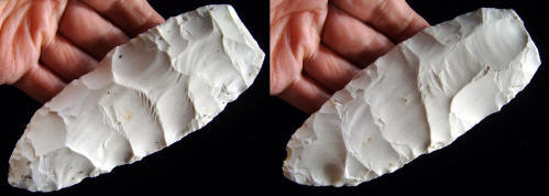
LATE STAGE BIFACE
LATE STAGE CLOVIS BIFACE
This is the largest biface in the McKinnis cache and the best
representation of a recognizable Clovis shaped artifact in the cache.
The lanceolate shape and "classic" Clovis flaking pattern suggests that
this is a late stage preform for a Clovis point. It was made with
edge-to-edge percussion flaking. Several large percussion flakes extend
nearly across one edge to the opposite edge. A large thinning flake was
also struck from the base. This late stage preform was made of
Burlington chert and it measures 5 5/8 inches (14.3 cm) long, 2 1/8
inches (5.3 cm) wide and 9/16 inch (1.4 cm) thick. THE McKINNIS CACHE SITE In 1996 a cache of 11 bifaces and 12 core blades were discovered on land that was being leveled for houses. The site is located on a hill top and within 2 miles of the Missouri River in St. Louis County, Missouri. This cache was made with stone tool manufacturing technology that relates to the Clovis culture. The largest artifact in the cache is a basally thinned late stage Clovis point preform. A base of a Clovis point was also found near this cache.
This picture shows three views of the original McKinnis cache biface. |
|
|
NOVEMBER
2009 CAST |
|
|
BIFACE
This early stage biface is one of 11 bifaces (see
McKinnis cache) discovered during a land leveling operation in St.
Louis County, Missouri. It's an early stage biface that illustrates
"classic" Clovis flake removal technique. Large percussion flakes have
been removed from several different directions. It has been demonstrated
that a rocker-punch technique or indirect style of flaking may be the
way Clovis people were making these small and the very large platter
biface cores. Clovis biface reduction was achieved by removing large
edge-to-edge percussion flakes from sides, corners and ends. This is a
lithic technology that was no longer in use in post-Clovis cultures. The
intended purpose for this early stage preform was probably to make a
fluted point. This biface is made of Burlington chert and measures 4 3/4
inches (12 cm) long, 2 5/8 inches (6.7 cm) wide and 3/4 inch (1.9 cm)
thick. THE McKINNIS CACHE SITE In 1996 a cache of 11 bifaces and 12 core blades were discovered on land that was being leveled for houses. The site is located on a hill top and within 2 miles of the Missouri River in St. Louis County, Missouri. This cache was made with stone tool manufacturing technology that relates to the Clovis culture. The largest artifact in the cache is a basally thinned late stage Clovis point preform. A base of a Clovis point was also found near this cache.
This picture shows three views of the original McKinnis cache biface. |
|
|
OCTOBER
2009 CAST |
|
|
|